Marine Geophysical Surveying
Marine geophysical techniques are often used to identify existing subsurface structural features, geological layers, and/or buried debris, infrastructure, and utilities. In urban waterfronts, decades of infrastructure construction, demolition, and abandonment have left structures and utilities in-place near critical facilities that require upgrades or rehabilitation. Many times, historic drawings for these facilities do not have accurate as-built data to identify the actual location of remnant underwater subsurface features. Marine geophysical surveys can help project stakeholders to identify subsurface conditions that might otherwise remain hidden to traditional bathymetric survey techniques and underwater investigations by divers.
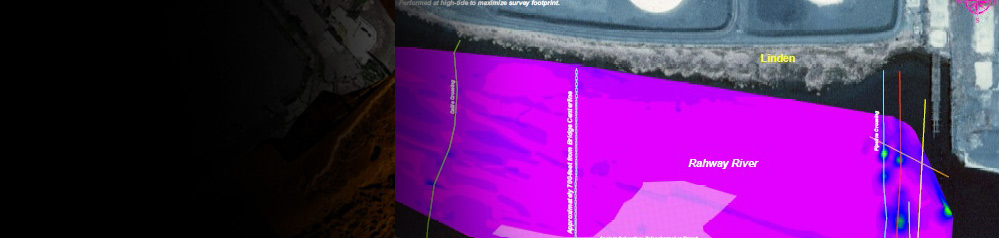
Sub-bottom profiling is the technique whereby lower frequency sonar units are used to profile through the water column and into the subsurface; the lower sonar frequency allows the signal to penetrate the subsurface and reflect back to the sonar with subsurface features such as stratigraphy, buried structures, and buried utilities highlighted in the cross-section imagery. Marine magnetometer surveys utilize sensitive magnetic sensors to measure the earth’s ambient magnetic field and deviations to that field that may be caused by ferrous objects such as pipelines, cables, steel structures or steel sheet piling. Likewise, electromagnetic (EM) surveys utilize conductive coils that also interact with metallic objects and may be utilized to survey the submerged, buried location of items such as pipelines, cables or buried unexploded ordinance (UXO).
Marine geophysical surveys are more interpretive than traditional bathymetric survey techniques, but they are often required to assess critical subsurface conditions that could bear serious consequences on marine construction and dredging activities. Hibbard Inshore strives to perform these surveys by leveraging the standards and techniques required by bathymetric surveys and applying them to our geophysical services in so far as the techniques will allow. This requires a dedicated focus to robust positioning, horizontal and vertical datums, proper QA/QC, and clear communication of the limitations of any geophysical survey methodology that may be applied. In turn, we are committed to collecting, processing, and delivering our survey products so that engineers, contractors, and stakeholders may integrate our geophysical survey products into their historic and/or new design drawings for their sites so that they may properly assess the impacts that our findings may bear on their projects.
Hibbard Inshore’s survey team has conducted marine geophysical surveys for projects throughout the United States while working under contract to several professional engineering, surveying, and marine construction companies servicing waterfront property owners. Hibbard Inshore supports waterfront inspection, assessment, dredging, and construction projects by supplying critical geophysical information in the form of CAD and GIS-compatible deliverable product.
Request a Consultation
Fill out the form on our contact page to request a consultation from a Hibbard Inshore expert: