Multibeam Bathymetric Surveying
Hibbard Inshore’s survey team has been performing multibeam bathymetric surveys with a specific focus on delivering high-quality data that affords maximum suitability for a variety of design and visualization applications. We survey ports, harbors, rivers, lakes and reservoirs inshore, as well as in the open ocean offshore. Working in accordance with the standards set by the U.S. Army Corps of Engineers and the International Hydrographic Organization, we aim to meet or exceed the standards of accuracy, resolution, survey coverage, and delivery requirements set for every project.
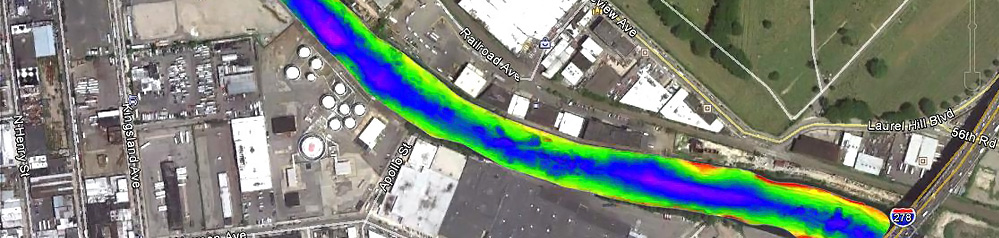
As opposed to traditional singlebeam bathymetric survey techniques that produce soundings on discrete profiles, multibeam bathymetry affords the end user with a highly detailed, densely spaced grid of soundings in the form of a geographically referenced digital terrain model. This model can support engineering design, construction, and dredging projects. The key advantages to multibeam bathymetry, as opposed to singlebeam bathymetry, are: increased data coverage, greater data density, and greater survey production capacity.
While cross-sections and contour drawings are standard derivative products, the high resolution and substantial underwater coverage of the data lends toward the generation of 2D and 3D models. These models can be fed into a variety of computer-aided design (CAD), geographic information system (GIS) packages, and even ubiquitous visualization software such as Google Earth®. Engineers, contractors, and even less technically experienced personnel may view the data and better understand underwater conditions. By using multibeam bathymetric survey techniques and this processing, features such as unique underwater geology, submerged debris, scour around bridges or other structures, and submerged pipelines/utilities can be better visualized.
Hibbard Inshore’s survey team has conducted bathymetric surveys for projects in the United States Canada, the Caribbean, and at the U.S. Naval Facility at Diego Garcia, British Indian Ocean Territory. In support of several professional engineering, surveying, and marine construction services to waterfront property owners throughout the Port of New York and New Jersey, Hibbard Inshore has been supporting waterfront inspection, assessment, and construction projects by supplying critical bathymetric survey services that draw upon singlebeam and multibeam bathymetric survey techniques, RTK-GPS positioning, and integration with computer-aided drafting (CAD) and geographic information system (GIS) deliverable products.
Request a Consultation
Fill out the form on our contact page to request a consultation from a Hibbard Inshore expert: